 GeoData.NZ
SOUTHERN OCEAN
Type of resources
Available actions
Topics
Keywords
Contact for the resource
Provided by
Years
status
-
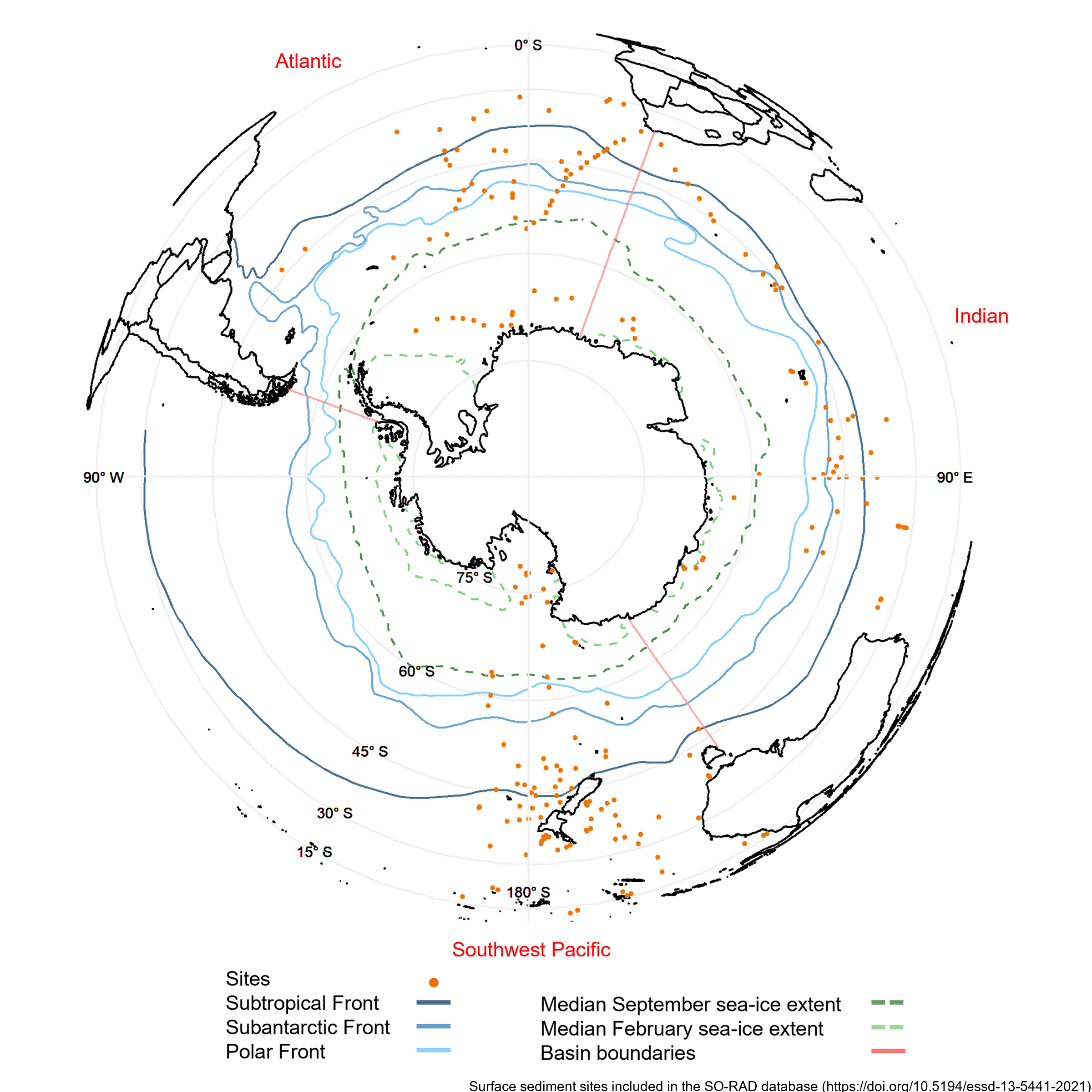
Radiolarians (holoplanktonic Protozoa) found in marine sediments are commonly used in Southern Ocean as palaeoclimate proxies. Generating such reconstructions of past climate based on radiolarian abundances requires a spatially and environmentally comprehensive reference dataset of modern radiolarian census counts. The Southern Ocean RADiolarian (SO-RAD) dataset includes census counts for 237 radiolarian taxa from 228 surface sediment samples located in the Atlantic, Indian and South-west Pacific sectors of the Southern Ocean. This compilation is the largest radiolarian census dataset derived from surface sediment samples in the Southern Ocean. The SO-RAD dataset may be used as a reference dataset for palaeoceanographic reconstructions, or for studying modern radiolarian biogeography and species diversity. RELATED PUBLICATION: https://doi.org/10.5194/essd-13-5441-2021
-
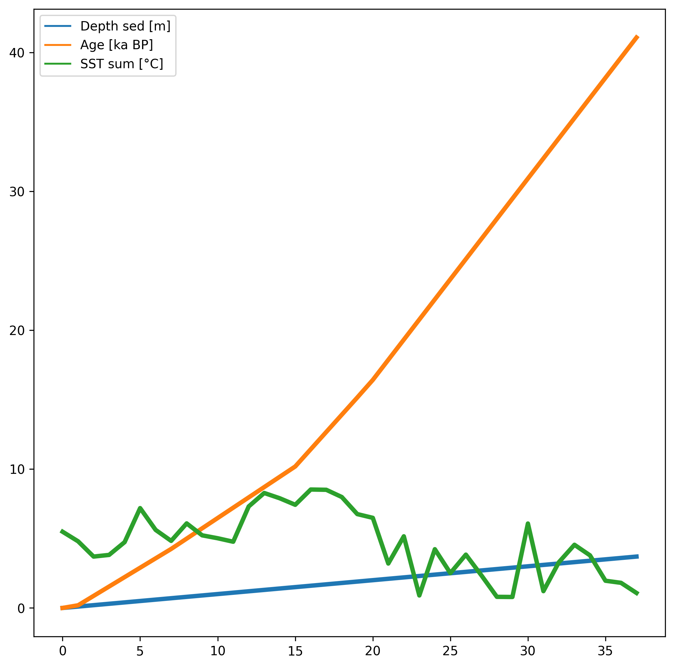
Diatom census counts were used to quantitatively estimate summer sea-surface temperatures (SST) over the last 40,000 years in core MD11-3353, collected in 2011 on board the R.V. Marion Dusfresne west of Kerguelen Island, Southern Ocean. The transfer function used to reconstruct summer (January to March) SST is the Modern Analog Technique that here uses 249 surface sediment samples (modern analogs), the relative abundances of 32 diatom species and the chord distance to select the five most similar modern analogs (Crosta et al., 2020). This method yields a root mean square error of prediction of ~1 °C. The core chronology is detailed in Thöle et al. (2019). RELATED PUBLICATION: Civel-Mazens, Matthieu; Crosta, Xavier; Cortese, Giuseppe; Michel, Elisabeth; Mazaud, Alain; Ther, Olivier; Ikehara, Minoru; Itaki, Takuya (2021): Impact of the Agulhas Return Current on the oceanography of the Kerguelen Plateau region, Southern Ocean, over the last 40 kyrs. Quaternary Science Reviews, 251, 106711, https://doi.org/10.1016/j.quascirev.2020.106711
-
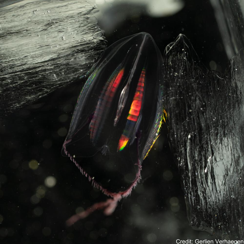
This Zenodo dataset contain the Common Objects in Context (COCO) files linked to the following publication: Each COCO zip folder contains an "annotations" folder including a json file and an "images" folder containing the annotated images. Verhaegen, G, Cimoli, E, & Lindsay, D (2021). Life beneath the ice: jellyfish and ctenophores from the Ross Sea, Antarctica, with an image-based training set for machine learning. Biodiversity Data Journal. https://doi.org/10.3897/BDJ.9.e69374 GET DATA: https://doi.org/10.5281/zenodo.5118012 GET DATA: http://ipt.pensoft.net/resource?r=life_beneath_the_ice-jellyfish_and_ctenophores_from_the_ross_sea_antarctica&v=1.3
-

The data set contains water temperature, salinity, and oxygen taken by CTD during three hydrographic sections perpendicular to the slope in the Western Ross Sea between Cape Adare and the Drygalski Trough. Data are in NetCDF. RELATED PUBLICATION: https://doi.org/10.1038/s41598-021-81793-5 GET DATA: https://www.ncei.noaa.gov/archive/accession/0219916
-
The Southern Ocean Freshwater Input from Antarctica (SOFIA) Initiative aims to improve our understanding of the simulated response to Antarctic freshwater input, and in particular the model uncertainty. The initiative has developed an experimental protocol and is engaging with modelling groups from around the world to run this common set of experiments using a variety of coupled climate and ocean-only models. Data from this international multi-model ensemble is openly shared for analysis, and is being synthesized into a series of publications by SOFIA participants. Full details are provided at https://doi.org/10.5194/gmd-16-7289-2023 GET DATA: https://sofiamip.github.io/data-access.html
-

Here we present physico-chemical data collected during two research cruises conducted to and across the Ross Sea, Antarctica in the summer of 2018 (February-March) and 2019 (January-February). The dataset includes measurements of temperature, salinity, oxygen, par and transmissivity obtained with a Sea-Bird Electronics (SBE) 911plus CTD. The CTD sensor was configured with SBE 3plus, SBE 4, and SBE 43 dual sensors for the parameters above, in addition to a seapoint fluorescence sensor, and a photosynthetically active radiation (PAR) sensor (Biospherical Instruments QCP‐2300L‐HP). These data were used to provide oceanographic context to DNA metabarcoding analysis of 18S rRNA V4 region that was carried out on DNA samples collected in parallel to nutrient and chlorophyll-a samples. Fastq samples from DNA metabarcoding analysis and the associated metadata (including nutrients, Chlorophyll-a, and size-fractionated chlorophyll-a) were deposited to GenBank under project numbers PRJNA756172 (2018 cruise) and PRJNA974160 (2019 cruise). The study resulting from this analysis has been submitted to Limnology and Oceanography. RELATED PUBLICATION: Cristi, A., Law, C.S., Pinkerton, M., Lopes dos Santos, A., Safi, K. and Gutiérrez-Rodríguez, A. (2024). Environmental driving forces and phytoplankton diversity across the Ross Sea region during a summer–autumn transition. Limnol Oceanogr. https://doi.org/10.1002/lno.12526
-
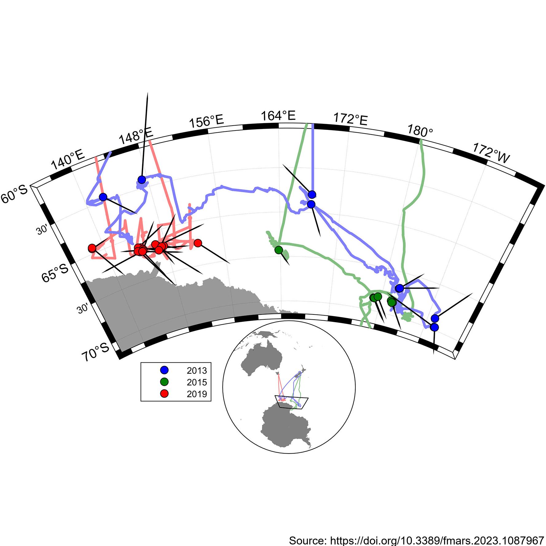
During the 2019 ENRICH Voyage of the CSIRO vessel, RV Investigator, a digital photogrammetric video tracking system was used to collect precise surfacing locations during encounters with mainly Antarctic blue whales, but also some fin whales. The photogrammetric video tracking system is a modern digital video version based on the same operating principle as the that described by Leaper and Gordon 2001, and enables determination of the range and bearing to tracked objects relative to the ship. Video tracking was conducted on 24 occasions for a total of 18 hours. Focal follows were aborted when it was no longer possible to follow the focal animal due to ice or when the presence of other animals meant it was no longer possible to be sure which was the focal animal. Calderan SV, Leaper R, Andrews-Goff V, Miller BS, Olson PA, Reyes MVR, Bell E and Double MC (2023) Surfacing rates, swim speeds, and patterns of movement of Antarctic blue whales. Front. Mar. Sci. 10:1087967. https://doi.org/10.3389/fmars.2023.1087967 GET DATA: https://doi.org/10.26179/tcbe-4h63
-
The data is generated through modelling simulations using the University of Victoria Earth system climate model. The modelling dataset presented here corresponds to the study entitled "Transient response of Southern Ocean ecosystems during Heinrich stadials". This dataset contains data files of the complete transient simulations (FW,FE and FWFE) and 40ka-control simulation mentioned in Table 1 and Table 2 of the manuscript. We first performed a control simulation 40ka-control integrating a total of 10000 years. We use only the last 200 years of this control simulation for our analysis. The data is generated through modelling simulations using the University of Victoria Earth system climate model. All the final data is in nc format, which can be easily read by Python/ferret or any other common data analysing software. RELATED PUBLICATION: Saini,H., Meissner,K.J., Menviel,L., & Kvale,K.(2024). Transient response of Southern Ocean ecosystems during Heinrich stadials. Paleoceanography and Paleoclimatology, 39, e2023PA004754. https://doi.org/10.1029/2023PA004754 GET DATA: https://doi.org/10.5061/dryad.k3j9kd5dt
-
Here we analysed 26 years of pigment data (14,824 samples between 32°S and the Antarctic coast) from over 50 voyages (1996 – 2022), using the phytoclass software. The analysis confirms that the Antarctic Polar Front (APF) is a circumpolar phytoplankton class boundary, separating haptophyte dominated communities to the north from diatom domination of chlorophyll a in the south, and thereby a biological analogue corresponding to the Biogeochemical Divide. Further details can be found at : Hayward, A., Pinkerton, M.H., Wright, S.W. et al. Twenty-six years of phytoplankton pigments reveal a circumpolar Class Divide around the Southern Ocean. Commun Earth Environ 5, 92 (2024). https://doi.org/10.1038/s43247-024-01261-6